Okay, these aren't Northeast levels of snowfall (the purple bars, with quantities up toward the top), but they're enough to potentially put a crimp in some weekend plans in the Denver area.

61 view(s)
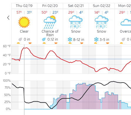
Okay, these aren't Northeast levels of snowfall (the purple bars, with quantities up toward the top), but they're enough to potentially put a crimp in some weekend plans in the Denver area.
Very low percentage chance for the big numbers though.
Still have a Winter Storm Warning on tap:
—–
… Winter Storm Watch in effect from Friday afternoon through late Sunday night…
The National Weather Service in Denver has issued a Winter Storm Watch… which is in effect from Friday afternoon through late
Sunday night.
* Timing… precipitation will begin Friday afternoon and evening as a rain/snow mixture but will quickly turn over to snow by
Saturday morning. The snow on Saturday will be heavy at times… especially over portions of the Denver Metro area and Palmer Divide. Snow will continue through Sunday morning and will begin to taper off by Sunday afternoon and evening.
* Snow accumulations… amounts of 8 to 16 inches will be possible for the plains with higher amounts closer to the foothills and
near the Palmer Divide.
* Wind/visibility… sustained winds on the plains of 10 to 15 with gusting up to 25 will be possible by Sunday morning. This will cause reduced visibility to under a mile at times during the heavier snowfall.
* Impacts… roads will become snow packed and icy starting Saturday morning into the afternoon. Persistent snow over the weekend will keep travel hazardous.
Precautionary/preparedness actions…
A Winter Storm Watch means there is a potential for significant snow that may impact travel. Continue to monitor the latest forecasts.